rooozt · Province
Hotels in Trat
Trat is a province in eastern Thailand. Compare real-time hotel prices in Trat across multiple OTAs on rooozt — ranked transparently with rooozt Score.
Where is Trat?
rooozt places Trat at latitude 12.2436, longitude 102.5151. Measured as a straight line across the Earth's surface, Trat lies about 280 km south-east of Bangkok. Of the provinces rooozt covers in eastern Thailand, Trat is the southernmost one. Trat is a coastal destination in rooozt's own destination data. Every distance on this page is a great-circle distance between coordinates — not road distance, and not travel time.
Coordinates come from the GeoNames database (CC BY 4.0). A Thai province resolves to its provincial capital, and an island or state resolves to its main town.
Trat weather month by month
10-year averages (2016–2025) from real daily records — not a forecast
In Trat the hottest month is February, averaging a daily high of 32.2°C, and the coolest is January, averaging a daily low of 22.4°C. July is the wettest month, averaging 588 mm, while December is the driest at 30 mm. Over a full year that comes to 3,148 mm of rain. The stretch averaging less than half this destination's monthly mean is November–March.
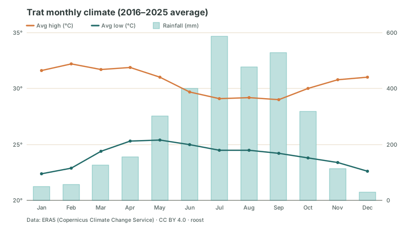
| Month | Avg high | Avg low | Rainfall |
|---|---|---|---|
| January | 31.6°C | 22.4°C | 49 mm |
| February | 32.2°C | 22.9°C | 56 mm |
| March | 31.7°C | 24.4°C | 127 mm |
| April | 31.9°C | 25.3°C | 156 mm |
| May | 31.0°C | 25.4°C | 301 mm |
| June | 29.7°C | 25.0°C | 401 mm |
| July | 29.1°C | 24.5°C | 588 mm |
| August | 29.2°C | 24.5°C | 478 mm |
| September | 29.0°C | 24.2°C | 529 mm |
| October | 30.0°C | 23.8°C | 319 mm |
| November | 30.8°C | 23.4°C | 114 mm |
| December | 31.0°C | 22.6°C | 30 mm |
These are 2016–2025 averages from ERA5, a reanalysis dataset on a roughly 9 km grid — not a reading from a single weather station, and not a forecast for the dates you travel. Grid-cell rainfall typically reads higher than a nearby weather station records, especially in mountainous areas, so check the national met service for exact rainfall figures.
Weather data: Open-Meteo Historical Weather API (ERA5 reanalysis, CC BY 4.0), 2016–2025.
Best value stays right now
Real-time pricesReal prices from Agoda · Stay Oct 15 – Oct 16 · ranked with rooozt Score
Destinations near Trat
The 6 rooozt destinations closest to Trat, nearest first by straight-line distance between coordinates — not by popularity or price.
Other provinces in eastern Thailand on rooozt
rooozt has price-comparison pages for 7 destinations in this group. The 4 nearest are listed above; here are 2 more.
Frequently asked questions
›How does rooozt find hotels in Trat?
rooozt compares real-time hotel prices in Trat across multiple OTAs and ranks results transparently with rooozt Score — no property can pay for a better rank.
See how rooozt Score ranking works →›Who do I book with in Trat?
rooozt is a hotel metasearch, not a seller — booking sends you to complete payment directly with the OTA partner (e.g. Agoda). rooozt may earn a commission from partner links — this never raises the price you pay, and never affects ranking.
›When's the best time to book a hotel in Trat?
Timing affects price — rooozt’s general guidance on how far ahead to book lives on the "Best Time to Book" page. Always re-check live prices for your actual dates before deciding.
See Best Time to Book →›Which part of Thailand is Trat in?
Trat is in eastern Thailand. It's also one of Thailand's coastal provinces.
›How far is Trat from Bangkok?
Measured as a straight line between coordinates, Trat is about 280 km south-east of Bangkok. That is great-circle distance — not road distance, and not travel time.
›What destinations are near Trat?
The rooozt destinations closest to Trat are Chanthaburi (about 60 km) · Rayong (about 140 km) · Sa Kaeo (about 180 km). Distances are straight-line between coordinates, not road distance.
›What is the weather like in Trat?
Averaged over ten years (2016–2025), Trat is hottest in February with an average daily high of 32.2°C and coolest in January with an average daily low of 22.4°C. It receives about 3,148 mm of rain a year. These are historical ERA5 averages, not a forecast.
›Which month is driest in Trat?
The driest month in Trat is December, averaging 30 mm. The wettest is July at 588 mm. These are ten-year ERA5 historical averages, not a forecast for this year.
Ready for Trat?